West County Ride – Petaluma To Marshall
I’m sure many of you have heard of, been to, or ridden your bike around the Healdsburg area. Places like the Dry Creek Valley, Alexander Valley, Chalk Hill, the Russian River, Sebastopol, even Bodega Bay. And if you have not been to these places get out and check out the wineries, restaurants, and natural beauty of the area.I want to share with you an area called West County. It is a large area west of Highway 101 extending out to the Pacific Ocean, south of Bodega Bay down Hwy 1 to Stinson Beach.
Towns or wide spots in the road like Tomales, Freestone, Valley Ford, the Coast Guard Station, Dillion Beach, Marshall, Pt Reyes Station, Olema, Rancho Nicasio, Bolinas. In between these towns are miles and miles and miles of rolling hills, this time of year, after some rain, are covered in lush green grasses perfect food source for the dairy cows and sheep that populate the region.Places to check out: the bakery, cheese tasting, wine tasting in Freestone, the bakery in Tomales, the beach in Dillion Beach, food and shops in Valley Ford, Pt. Reyes National Seashore, the Lighthouse, the oysters in Marshall, shops and food in Pt. Reyes, Stinson Beach.
The cycling out here is awesome and diverse. You can ride 50, 60, 70 miles relatively flat or there is plenty of climbing to be had. Most of the roads have been recently paved and on the main roads Petaluma-Valley Ford Rd. / Petaluma-Tomales Rd. a 4 ft’ shoulder exists.
Recently I took off from Petaluma (10:45) heading to Novato to watch my daughter’s basketball game which started at 3:00. Started out on Western Ave, made a left on Chileno Valley Rd which merges into Wilson Hill Rd. you are now out in the country side. Wilson Hill is about an 800′ climb three arrows on the bike map. I rode up on a couple and asked them where they were headed and they said “to the top of Wilson Hill for the 3rd time”. Listening to them talk for a few minutes it sounded like they were on a first date.
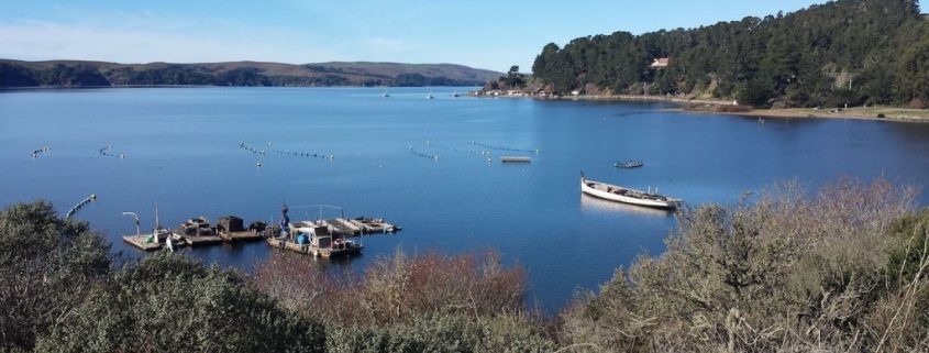
At the top of Wilson Hill stop for a minute, catch your breath, have a drink, and look back behind you over Petaluma toward Sonoma, beautiful! Down at the bottom make a right onto Petaluma-Marshall Rd. The road winds and rolls past dairy ranches with cows and old farming equipment to entertain you along the way. You’ll come out of the valley and up on the old Synanon Ranch (Google Synanon for some interesting reading) and onto the next climb, Marshall Wall, another 3 arrow climb. Once at the top, on a clear day you will get your first view of the Pacific and Tomales Bay; enjoy the ride down to Hwy. 1 and Tomales Bay.
I made a left heading to Marshall (they should re-name it Oyster-ville). After an hour and a half of smelling fresh air and Eucalyptus trees, you can smell the deep fryer of Nick’s Cove before you can see it. Nick’s Cove is one of four restaurants in Marshall specializing in Oysters. The ride south heading to Pt. Reyes Station parallels Tomales Bay and the Oyster beds. The road is freshly paved, rolling along beautiful scenery. I watched a guy training his spaniel how to fetch.
Before you come into Pt. Reyes there is a fork in the road, right into town or left back to Petaluma or Novato (16 miles for each). Riding past Nicasio Reservoir, water was coming out of the spillway; 30 days ago it was 40′ low, glad to see it full. One last big climb to get done, there’s been a bit of a head wind from Marshall, coming out of the south. Grinded out the climb (another 3 arrows on the bike map), down the hill, through the bay trees, past the cheese factory and on into Novato. It is 9 miles to Novato if you go right or 9 miles to Petaluma if you go straight. There is another climb if you are going to Petaluma. Made it to Novato and my daughter’s game at 2:45. Statistic: 49.6 miles, 4 hours 5 minutes, 40.02 max speed, 3960 ascent, 2937 calories, 13.4 avg. speed.
Good Riding!


